- (760) 964-4351
- info@mikecodylandsurveying.com
- License: 10121
Mike Cody Land Surveying provides professional land surveying services in Palmdale, California for property owners, builders, contractors, developers, real estate professionals, and landowners who need accurate survey information before moving forward with a project.
Palmdale includes residential neighborhoods, rural parcels, commercial development areas, open desert land, hillside properties, and construction sites where accurate land data can make a major difference. With High Desert surveying experience dating back to 2004, Mike Cody provides dependable surveying support for boundary, topographic, construction, and documentation needs.
Land surveying in Palmdale can support many different types of property and construction needs. Some clients need a boundary survey to better understand property lines. Others need topography for design planning, construction staking for site work, a lot survey before buying or selling property, or a legal description for documentation.
Because Palmdale has both developed neighborhoods and wide-open land areas, survey requirements can vary significantly from one project to the next. A property may include existing improvements, access roads, easements, slopes, drainage considerations, or record information that needs to be reviewed carefully before decisions are made.
Mike Cody Land Surveying helps clients receive practical and accurate information for residential, commercial, rural, and development-related properties. The goal is to provide dependable survey data that supports planning, construction, property review, and project coordination.
Boundary surveys help identify property lines, corners, and boundary-related conditions. These surveys are often helpful before fencing, building, buying, selling, or resolving uncertainty about land ownership limits.
Lot surveys provide useful information about parcel dimensions, property layout, and site conditions. They can support real estate transactions, vacant land review, and future improvement planning.
Record surveys help document surveyed information and may be needed when property boundaries, improvements, or survey conditions require formal documentation for records or project use.
Boundary and easement exhibits provide clear visual references for property limits, access routes, utility areas, and other land-use details that may affect a project or parcel.
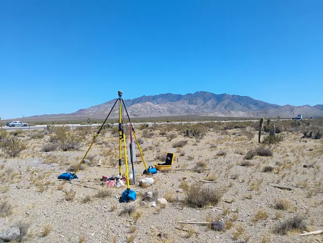
Topography surveys map elevations, slopes, drainage patterns, and existing site features. This information can support grading, engineering, design, drainage planning, and construction preparation.
Construction staking helps transfer plans to the physical job site. Accurate staking supports grading, foundations, utilities, roads, driveways, and other planned improvements.
The type of land survey you need depends on your project goal. A homeowner may need boundary clarity before improving a property, while a contractor may need staking for construction layout. A developer may need topography, exhibits, or legal descriptions to support planning and documentation.
| Surveying Service | Common Use in Palmdale | Helpful For |
|---|---|---|
| Boundary Survey | Reviewing property lines, corners, and boundary conditions | Homeowners, landowners, buyers, sellers |
| Lot Survey | Understanding parcel size, shape, and property layout | Residential lots, vacant land, real estate transactions |
| Topography Survey | Mapping elevations, slopes, drainage, and site features | Design, grading, drainage, construction planning |
| Construction Staking | Marking field points from approved plans | Contractors, builders, grading crews |
| FEMA Certificates | Providing elevation or flood-related information when required | Insurance, permitting, property review |
| Legal Descriptions | Preparing written descriptions for deeds or survey documentation | Transactions, records, lot line adjustments |
Palmdale properties can present a wide range of surveying needs. Some properties are located in established residential neighborhoods where owners need boundary information before improving a home. Other properties may be larger parcels, vacant land, or development sites where access, slopes, easements, and site conditions require careful review.
A professional land survey can help clarify property limits, document site conditions, and provide important information for project planning. This can be especially helpful before installing fences, building walls, grading land, adding structures, preparing construction plans, or buying and selling property.
For contractors and builders, surveying can reduce confusion between plans and field conditions. Construction staking helps place improvements accurately, while topography surveys provide site data that may be needed for design, grading, drainage, and engineering coordination.
For real estate and vacant land situations, surveying can provide a clearer understanding of parcel boundaries and physical conditions before major decisions are made. Instead of relying only on assumptions, visible features, or informal information, a survey provides measured data prepared by a licensed professional.
The surveying process begins by understanding the property, the project goal, and the reason the survey is needed. A boundary survey, topography survey, construction staking request, FEMA certificate, or legal description may each involve a different scope of work.
Share the property location, parcel details, and survey need.
Available property records and project information are reviewed.
Measurements and site data are gathered in the field.
Survey information is prepared for your property or project.
Land surveying in Palmdale can support everything from individual residential improvements to larger construction and development projects. A homeowner may need help understanding where a property line is located before installing a fence or planning an addition. A builder may need construction staking to place improvements accurately. A landowner may need a survey before selling, developing, or adjusting parcel boundaries.
Vacant land can create its own challenges. Without obvious improvements or visible boundary evidence, it can be difficult to understand where a parcel begins and ends. A survey can provide important information that helps buyers, sellers, and owners make more informed decisions.
Topography is also important for many Palmdale sites. Slopes, drainage, access, existing improvements, and natural features may affect how a property can be planned or improved. A topography survey can help designers and contractors better understand the land before plans are finalized.
When construction begins, staking can help bring the design from the plan set to the field. This allows contractors to work from accurate field points and helps reduce layout confusion during grading, foundations, utilities, driveways, and other improvements.
Mike Cody Land Surveying provides professional land surveying services for Palmdale and surrounding High Desert communities. Services are available for residential lots, rural parcels, vacant land, construction sites, commercial properties, and development-related projects.
If you are not sure which survey service you need, start by explaining the property location and the reason for the request. Common reasons include property line questions, planned construction, grading, real estate transactions, lot line adjustments, topography, FEMA-related documentation, boundary exhibits, or legal descriptions.
You should consider requesting a land survey before building improvements, installing fencing, buying or selling property, planning grading, adjusting a lot line, or resolving uncertainty about property boundaries.
A boundary survey is typically used to help identify property lines, corners, and boundary-related conditions. This can be helpful for homes, vacant land, commercial sites, and development properties.
Yes. A topography survey can help document elevations, slopes, drainage patterns, and existing site features that may be important for grading, design, engineering, and construction planning.
Yes. A survey may help buyers better understand parcel boundaries, land layout, access considerations, and site conditions before making decisions about a vacant property.
You can request a quote by providing the property address or parcel information, the type of survey needed, and any project details such as plans, boundary questions, agency requirements, or deadlines.
Get professional land surveying support from a licensed High Desert land surveyor with more than 20 years of local experience.